A Hybrid Conditional Random Field for Estimating
the Underlying Ground Surface from Airborne LiDAR Data
IEEE Transactions on Geoscience and Remote Sensing
the Underlying Ground Surface from Airborne LiDAR Data
IEEE Transactions on Geoscience and Remote Sensing
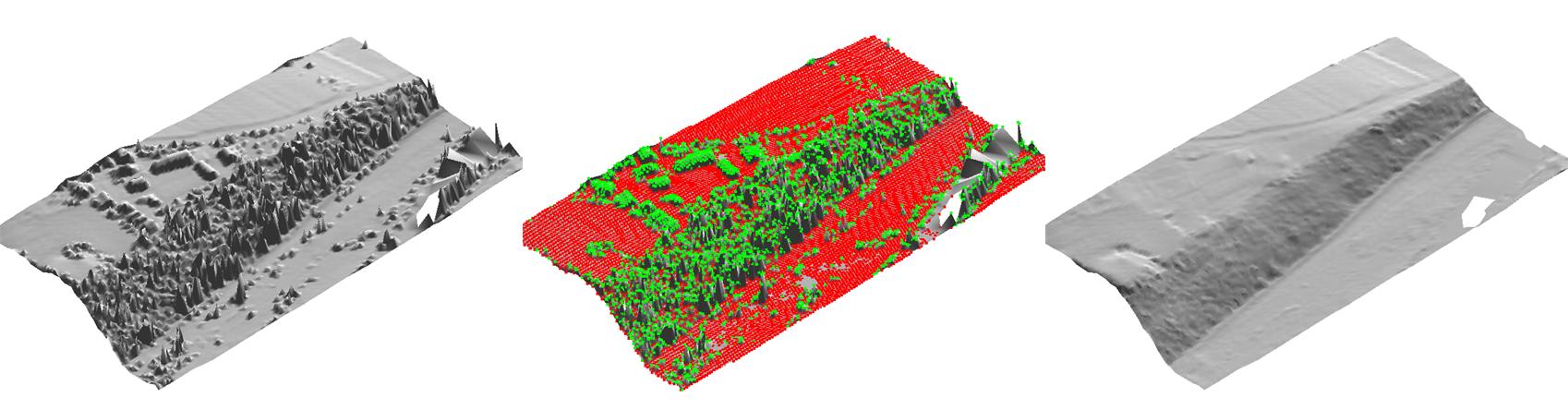
Left: The original DSM of a rural site with vegetation on a slope, and some small buildings.
Middle: The classification of 3D points to ground/non-ground (red/green).
Right: The extracted DTM of the bare-earth surface. The small white patch near the top right corresponds to missing data.
Abstract
Recent advances in airborne light detection and ranging (LiDAR) technology allow
rapid and inexpensive generation of digital surface models (DSMs), 3D point clouds
of buildings, vegetations, cars, and natural terrain features over large regions.
However, in many applications, such as flood modeling and landslide prediction,
digital terrain models (DTMs), the topography of the bare-earth surface, are needed.
This article introduces a novel machine learning approach to automatically extract
DTMs from their corresponding DSMs. We first classify each point as being either
ground or non-ground, using supervised learning techniques applied to a variety of features.
For the points which are classified as ground, we use the LiDAR measurements as an estimate
of the surface height, but for the non-ground points, we have to interpolate between nearby
values, which we do using a Gaussian random field. Since our model contains both discrete
and continuous latent variables, and is a discriminative (rather than generative) probabilistic
model, we call it a hybrid Conditional Random Field. We show that a MAP estimate of the
surface height can be efficiently estimated by using a variant of the Expectation Maximization
(EM) algorithm. Experiments demonstrate that the accuracy of this learning-based approach
outperforms the previous best systems, based on manually tuned heuristics.
Paper

PDF (9.7M)
BibTeX
@ARTICLE{Lu:2009,
author = {Wei Lwun Lu and Kenji Okuma and James J. Little},
title = {A Hybrid Conditional Random Field for Estimating the Underlying Ground Surface from Airborne
LiDAR Data},
journal = {IEEE Transactions on Geoscience and Remote Sensing},
year = {2009},
volume = {To Appear}
}
author = {Wei Lwun Lu and Kenji Okuma and James J. Little},
title = {A Hybrid Conditional Random Field for Estimating the Underlying Ground Surface from Airborne
LiDAR Data},
journal = {IEEE Transactions on Geoscience and Remote Sensing},
year = {2009},
volume = {To Appear}
}
Funding
This research is supported in part by
- GEOIDE Network of Centres of Excellence
- Terrapoint Canada (A division of Ambercore)
- National Science and Engineering Research Council of Canada (NSERC)
- Canadian Institute for Advanced Research (CIAR)